
Home About Us History of District Judiciary
The world poet Rabindranath Tagore wrote to his close companion Shailajaranjan Majumdar, overwhelmed by the scenic description of Netrakona:
“Beyond the fence woven dreams of color in seasonal flowers
I have named the window Netrakona.
Netrakona is a district of Mymensingh Division of Bangladesh. It is located in the northern part of the country along the border of the Indian state of Meghalaya. The headquarters of this district is at Netrakona. The natural beauty of the landscape is eye-catching. It is home to many rivers including Kangsha, Someswari, Gonesswari, Dhala, Magra and Teorkhali. The district has the Garo hills in the north and several hills in the south.
Netrakona is an agricultural district. The main crops grown in the district are paddy, jute, wheat and vegetables. The district is also home to a number of industries, including the production of textiles, ceramics and food products. The district is home to several historical and religious sites, including the ruins of the ancient city of Sonargaon, the tomb of Sufi saint Hazrat Shah Jalal and the Netrakona Rajbari.
“Haor, Baor, hills, rivers and plains
This soil fills the eyes
Woven in the dreams of millions of people
The beauty of nature is the corner of our eye.”
(Md. Rafiquzzaman)
Naming history of Netrakona district
The naming history of Netrakona district is long and winding. The area was originally known as Natorkona, which means "Nator's corner" in Bengali. Natore is a district of Rajshahi division, and the zamindars (landlords) who controlled the area in the eighteenth century came from there. Eventually the name Natorkona was corrupted to Netrakona.
In 1880, the British Raj recognized the area as a Mahakuma (administrative territory) and named it Netrakona Mahakuma. The name Netrakona was officially adopted on 3 January 1882.
The name Netrakona is derived from the name of the village called Natarkona. The village is located in the north of Netrakona district town. In the late seventeenth century, the British government established an administrative center at Naterkona from where all activities were conducted in order to quell the 'mad rebellion'. However, later on, administrative activities were transferred from Naterkona to Kaliganj to facilitate sea communication and to avoid attacks by madmen. But the administrative documents of the English Government continued to be exchanged under the name Natterkona. As a result of sound changes through English, Natterkona > Neterkona > Neterkona > Netrokona.
Another popular legend about the naming of Netrakona is that the place is named Netrakona because of the eye of the river Magra flowing through Netrakona city. The name Netrakona is believed to have originated from the fact that the district headquarters was located at the end of the river Magra. In Bengali word "netra" means "eye" and word "kona" means "corner". So Netrakona literally means "corner of the eye". It is noted that the district is located at a strategic point where the Magra River meets the Someswari River.
History and Traditions of Netrakona District:
The history of Netrakona district situated on the eastern side of the Brahmaputra river is proud of its ancient tradition and various historical events. Various theoretical reviews clearly prove that the region became habitable land due to rising from the ocean or seabed. The watercourse of present Netrakona district originates from the rivers Kansa, Someswari, Ganeshwari, Maheshwari, Gorautra and other tributaries that lie along the foothills of the Garo hills. Every river in this district flows towards the south-east of the district. As a result, the land of the entire district is high in the north and gradually sloping in the south-east.
The region was under the Gupta emperors in the 4th century AD. It is known from the history reading that during the Gupta era, West Mymensingh, including this region under Samudragupta, belonged to the Kamrup kingdom. The kingdom of Kamrup was ruled by Kumara Bhaskar Varman, a Brahmin of Narayan descent, until the Chinese explorer Hugh N Tsang came to the Kamrup region in 629 AD at the invitation of the Hindu king Shashanka. In the late 13th century AD, the Vaishyagaras and Durgagaras ruled their fictitious kingdoms at Pahar Mullu in the northern part of East Mymensingh. In the late 13th century, a Muslim ruler invaded the eastern Mymensingh region and managed to establish Muslim rule for a short period of time. Then in the 14th century, a monk named Jitara attacked and occupied the Bhati region, the then capital of Kamrup. Even till that time the Muslim rulers and inhabitants could not stay and rule the area permanently. During the reign of Alauddin Hussain Shah (1493-1519) in the late fifteenth century AD, the entire Mymensingh region came under Muslim rule.
During the reign of Alauddin Hussain Shah's son Nasrat Shah (1519-1532) two rebellions took place but the rebels were unsuccessful. Nasrat Shah's rule was in force in the entire Mymensingh region. Although Nasrat Shah's footprints have disappeared, many of his memorials have stood the test of time. Neither the successors of Nasrat Shah (1533–1838) nor the other rulers of Lakshmanavati after him could maintain dominance over the Mymensingh region. The northern part of Mymensingh was re-subjugated by the Kochs. The rest came under the rule of the Delhi Pathan Sultan Sher Shah (1539-1545). The reign of his son Salim Shah (1545-1553) was full of rebellion and unrest. Far away from the capital Delhi and taking advantage of the weakness of the central government, Chief Revenue Secretary Dewan Sulaiman Khan (formerly known as Kalidas Ghazdani) defied the emperor. By doing this, the domestic and foreign kingdoms tried to occupy the area. Of these, the Bhati region (east-north) was occupied by Sulaiman Khan. Although Sulaiman Khan was killed by the troops sent by the central ruler, the elder of his two sons, Isha Khan, ruled the Bhati region from Khizirpur. After Isha Khan's death in September 1599 AD, the region was ruled by his grandson Musa Khan and the Afghan army Khwaja Usman Khan. During the reign of Emperor Jahangir (1605-1627), the entire Mymensingh region came under the Mughal Empire.
Many forts were established due to the war tactics of the Mughal armies. Apart from this, they also renovated and used the ruined forts made by the previous rulers. The ruins of those historical forts can still be seen. Notable among these is Roai Bari Durg, which was later used as the residence hall of Isha Khan Parishad Masjid Jalal. Many monuments, including the ruined fort of Pukuriya near Netrakona Sadar, have been lost to the ground. However, there are some traces of history here. Besides, many philanthropic works of the rulers of that time can be found. Among them are the reservoirs known as the Khojar Dighi. Many believe that Khan dug the wells as a philanthropic water supply system on the land of the Khazads. So Khoja's Dighi from Khoja Khan's Dighi. It also has different opinions. Some think that Khwaja Dighi was derived from Khwaja Usman Khan's Dighi, and from him it came to be known as Khozar Dighi. The current location of Netrakona district comprises the lands of the then Susang, Nasirujial, Mymensingh, Sindha and Khaliajuri parganas.
British rule granted Netrakona subdivision in 1880 AD (reasons discussed in Netrakona Sadar chapter). Netrakona sub-division started on 3rd January 1882 AD. During the British period, peasant rebellion, Pagal Panthi rebellion, Tonk movement and Tevaga movement took place in this district. In 1945, a three-day All India Farmers' Conference was held at Nagara, the district headquarters.
During the Pakistan period, there was a public demand for the elevation of Netrakona subdivision to a district. In order to meet that demand, in 1962 the government acquired land for setting up the district headquarters at Kendua. But the plan of the government was not implemented. On January 17, 1984, Netrakona sub-division was declared as a district. (Government of the People's Republic of Bangladesh issued Notification No.-S-R, O 17-L/84/M,E,R(J,A-2)/264/83-30). The activities of the newly established district officially started from 1st February of the same AD.
The independence-minded people of Netrakona could understand that they have to go to war for freedom after listening to the summary of Bangabandhu Sheikh Mujibur Rahman's historic speech on March 7. Therefore, the people of Netrakona did not spend much time preparing for the liberation war. From March 7, the youth community became eager to go to war in every thana town of Netrakona. Every day thousands of armed people from the villages started marching at the police station level. Politically astute people of Thana towns including Netrakona town also started policy making work. Looking at the battlefields of Netrakona, it is seen that 50 brave freedom fighters of the then Netrakona sub-division have received martyrdom. Apart from the freedom fighters of Netrakona subdivision, many freedom fighters from different parts of the country fought in different battlefields of Netrakona and many were martyred.
Netrakona District and Sessions Judge Court:
District and Sessions Judge Court, Netrakona was established in 1984 AD. The first District Judge was Md. Abdul Jalil who joined At this Court on 01.09.1984 AD. Initially the proceedings of the Netrakona District and Sessions Judge Court were conducted in the old court building located in the Moktarpara area of Netrakona. There is an old railway station near the court house known as court station for the convenience of the litigants. At present, the activities of the Netrakona District and Sessions Judge Court are being conducted in the new building established in Jayanagar area of Netrakona city from 10.11.1992 AD.
Nari o Shishu Nirjaton Domon Tribunal, Netrakona:
Netrakona Women and Child Abuse Prevention Tribunal was established on 27.03.2014 AD. Later on 12.07.2016 AD Mr. Dr. AKM Abul Kashem joined as the first judge of Women and Child Torture Prevention Tribunal on 12.07.2016 AD.
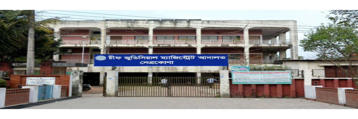
Court of Chief Judicial Magistrate, Netrakona:
Chief Judicial Magistrate Court Netrakona was established on 01 November 2007 AD after the separation of Judiciary. At the time of establishment, the Chief Judicial Magistrate of Netrakona was Mr. Md. Golam Kibria. At present there are a total of 12 judicial magistrate posts. As the Chief Judicial Magistrate Court Netrakona does not have its own building, the activities of this court are currently being conducted in the District and Sessions Judge Court.
Land Survey Tribunal, Netrakona
Land Survey Tribunal Netrakona was established vide notification dated 14.08.2013 with about 24,000 cases but then the Judge of Joint District and Sessions Judge 1st Court was performing the duties of Judge of Land Survey Tribunal in addition to his duties. Later on 09.02.2016 Mr. Kamal Hossain served as the first judge of Netrakona Land Survey Tribunal.
Chowki Court:
A Chowki Court was established in Durgapur Upazila of Netrakona in 1943 during the British period for this purpose so that all litigants of Netrakona district can get equal service. The first judge of this historic Durgapur Chowki Court was Mr. Nagesh Chakraborty who was serving as Senior Munsef. Currently there are 03 chowki courts namely Durgapur Senior Assistant Judge Court and Kalmakanda Assistant Judge Court and Durgapur Senior Judicial Magistrate Court.
District Bar Association Netrakona:
Netrakona District Bar Association is a traditional and rich bar. In 1887, Netrakona District Bar Association started its journey with the establishment of Netrakona District Bar Association. Later in 1984 Netrakona District Lawyers Association made its debut. The first President of the District Bar Association was Mr. A,K,M Fazlul Quader and the first General Secretary was A,K,M Mozammel Haque. The activities of the Netrakona District Bar Association were initially started in a tin shed building, but at present these activities are being conducted in a modern building.